Loading...

Cheaper when you book directly through our website

  • Free Car Parking and Wi-Fi

  • No Booking Fee

When would you like to join us?

Scroll Down Group 11 Created with Sketch.

Keeper Hill

Keeper Hill is situated in the Slieve Felim mountain range in North Tipperary and is just 15km east of Limerick City. The Gaelic name for the hill is Sliabh Coimeálta – the mountain of guarding! At a height of 694m, Keeper Hill is the highest mountain in the Shannon area and the 117th highest in Ireland. The ‘hill’ is wrapped in a forestry area of 3,300 hectares.
The 300 hectare summit is designated as a National Heritage Area, considered important for the habitats present or species of plants and animals whose habitat needs protection. This loop overlaps with a short section of the Slieve Felim Way – a 30km way-marked route which travels from Murroe in County Limerick to Silvermines in County Tipperary. En-route it passes through the small but pleasant village of Toor and onward across the shoulder of Keeper Hill.
While the loop (marked with purple arrows) explores the lower shoulders of Keeper Hill, the ‘hardy’ walker will enjoy incorporating the ‘trek’ to the summit (the red arrows). This loop walk is part of the National Looped Walks and is marked using the standard purple National Looped Walk directional arrows.

Routes

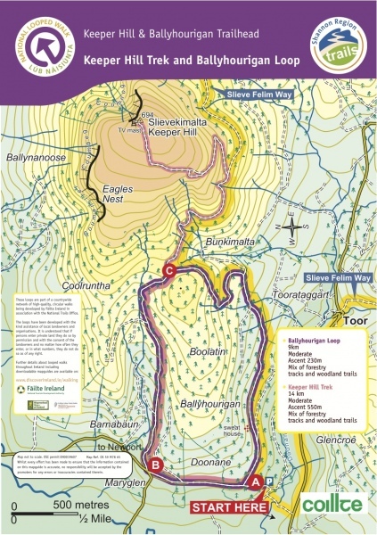
A-B. Starting from the car park follow the purple (and red) arrow northward along the laneway. The red arrows are for the longer trek to the top of Keeper Hill. After almost 2km the loop reaches a crossroads – turn right here and after 100m enter Ballyhourigan Woods via the metal barrier.

B-C. Ascend along the forestry roadway in the direction of Keeper Hill. After 3km the loop and trek separate at a 3-way junction. Here you have the choice of turning left and following the red arrows to the top of Keeper Hill – the return journey will take you 1hr-1hr30mins. The main loop turns right, following the purple arrow.

C-A. Continue to follow the purple arrows along the forestry roadway. Note that you are also following yellow arrows which are for the long-distance Slieve Felim Way. The loop sweeps south and descends to the townland of Boolatin – passing en-route a stone sweat house. After 4km you regain the trailhead.

Directions to Trailhead

From the village of Toor, follow the road (unclassified) in the direction of Newport. After 2km turn right onto a minor roadway and follow the Trailhead signs to reach the trailhead at Doonane.