


More...
About:
The village of Upperchurch is located near Thurles in Co. Tipperary and is twinned with the neighbouring parish of Drombane for many aspects of life including hurling (a traditional Irish sport played with sticks and a ball). The community has been invloved for many years in developing tourism products including hillwalking.
Folklore is alive and well in the area and includes tales of a Robin Hood figure known as Eamonn a Chnoic (Ned of the Hill) who roamed the halls in the 17/18th century. Eamonn a Chnoic became one of a band of raparees who championed the cause of the poor and many legends are told of these men and their deeds. This loop explores an area which is associated with Red Hugh O’Donnell – the last chieftan of Tir Conaill (County Donegal). Born in 1572, RedHugh is famed for his imprisonment in Dublin castle in 1587 and escape attempts in 1591 and 1592. Red Hugh had a crucial role in battles like the Battle of the Yellow Ford(1598) and the Battle of the Curlews(1599). But he was ultimately defeated at the Battle of Kinsale in 1601, having led his army along practically the entire length of Ireland, often covering over 40 miles a day, to meet his Spanish allies. In walking this loop you will be retracing his journey up and around the hill of Knockalough.
Routes
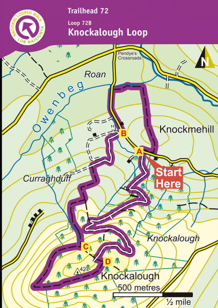
A-B. Starting from the forestry entrance, cross the road and climb the stile, following the purple (and green) arrows. The green arrows are for the shorter Red Hugh loop. The first section of the loop takes you through some fields to exit at a surfaced road where you turn left. Follow the surfaced road to reach the entrance to a farmyard on your right – turn right here.
B-C. Follow the sandy laneway keeping to the right of the shed and continue for about 600m to reach a gateway on your left where you enter a field and ascend. At the top of the field turn right and follow the green hedge to join a wire fence. where you turn left and climb again. After a 100m (at metal gates) you turn right – crossing a stile and joining a tractor trail alongside forestry. Follow the tractor trail and wire fence to reach a stile entrance to the forestry. Ascend steeply by the edge of the forestry to exit onto an old forest laneway where you turn right (downhill)
C-D. Follow this laneway around the edge of the forestry to reach a T-junction with a forestry road where you turn left and, after 100m, right to begin the downhill trek to the trailhead.
D-A. Continue to follow the forestry road downhill (picking up the green loop at a right bend) and on to reach the trailhead.
Directions to Trailhead
Start from the town of Thurles just off the national route N8 from Dublin to Cork. Take the R498 (signposted Nenagh) for 2.5km to reach a junction with the R503 (signposted Limerick). Follow the R503 for 13km to reach a crossroads with a signpost and stone nameplate for the village of Upperchurch. The village is to the right (just 300m) – well worth a visit. To reach the trailhead, however, you should turn left and travel 500m to reach a forestry entrance on your right.